Thursday, March 27, 2014

Not so Much North

Going home, we are heading east. And by going east, we pass through New Mexico.

So, who knew that New Mexico had volcanoes?  Anyone?  No? Neither did we. But just over the border from Arizona are two state monuments.  El Morro and El Malpais.

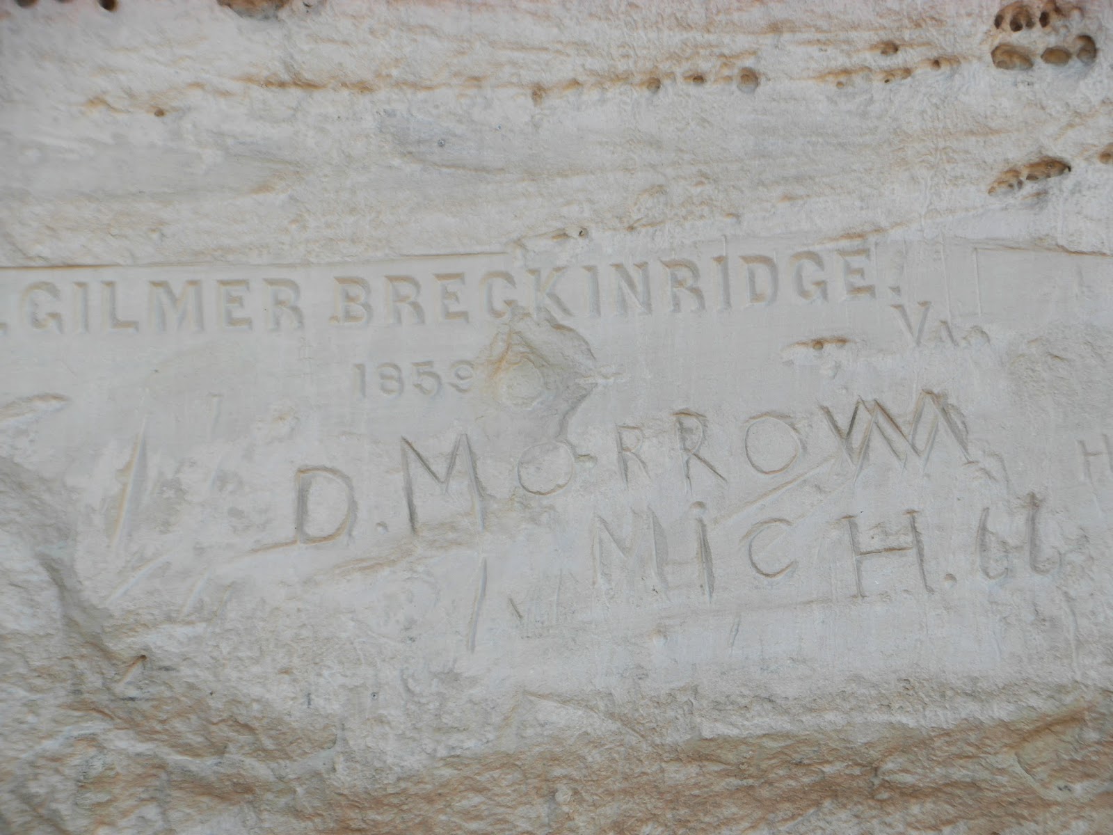
El Morro is all about petroglyphs of a different nature than what we've seen so far.


There are ancient ones, and there are also ones that are not so much ancient as about 400 years old or less.  Spanish conquistadors carved their names on a cliff near a common watering pool. This one is in Spanish and is dated  1692.


Settlers pioneering their way to a new life,  left a mark of their passage.

I love the names.


Some have fancy lettering and others are pounded into rock with horseshoe nails. It’s like a history page written on rock.


We came upon this place in the afternoon and barely had time to do the hike before they closed. Luckily they also allowed camping. It was “dry camping”, no water or electricity, so another chance to play with hubby’s new toy, the generator.

And it was free, so it was a win-win for us.


Not 20 miles down the road is El Malpais. Spanish for “Bad Lands”, this is where the volcanoes are. There are 40 odd volcanoes on the monument property. The last eruption was 10,000 years ago, but up until then, there were several blowups of cinders, ash, and molten lava flows.


We walked the trails beside lava tunnels, lava trenches, lava rocks, and cinder. Most areas have now been covered by new soil and plants. Even trees show the adaptability of nature and have grown through several lava flows to reach soil beneath.

But a lot of the area, up to 100 miles away, is still covered in black volcanic rock, barren and dark.


We walked up a volcano cone. The cinders at the base and down the side were black and red, indicating that there were two eruptions, an oxidized ash covering the black original ash.
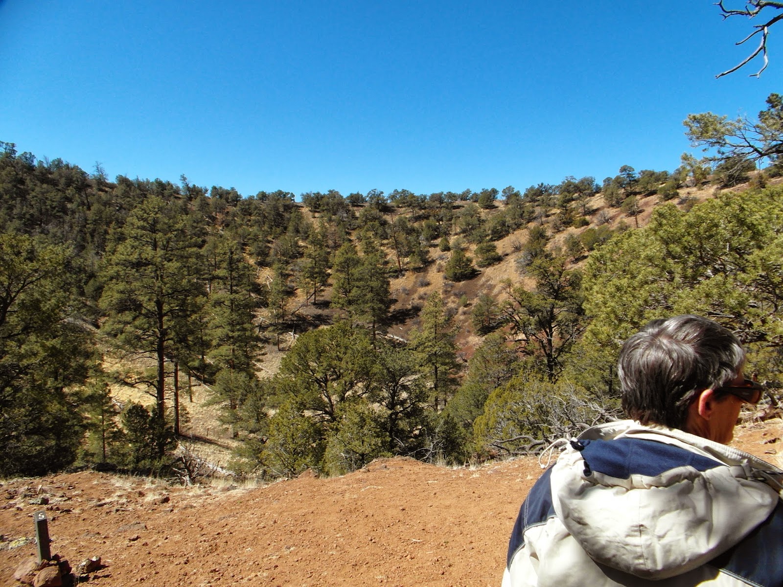


This is an old volcano, eroded with time. The cone itself isn’t very high and the inside is covered in trees and bushes.


From there we took a trip to Santa Fe. The old town section has all adobe buildings, little boutique stores, and two churches. At opposite ends of the spectrum, one church is over 400 years old with simple lines and originally adobe construction. The other is about 150 yrs and was supposed to be an emulation of the European Catholic churches.


We went on to Amarillo in northern Texas. The nights had been getting colder, and the days were sunny, but cool. Even in New Mexico we had one night where the temperature dropped down to -10C (14F). We planned to take a northeastern route, through Oklahoma City and St. Louis, gradually getting used to the cooler spring weather. But we were wearing winter coats and thermal underwear and we weren’t even out of Texas! The kicker was when we saw big trucks coming from Oklahoma. They were covered in frozen road slush and dripping ice.

The nice thing about our lifestyle is if we don’t like the weather, we leave. So we changed course, and headed south. We figured if we only have two more weeks left in the States, we may as well go someplace warm and enjoy it.


So here we are in southern Alabama, right near the gulf coast. We can finally break out our shorts and put away the winter coats and hoodies.

At least for another week.


W

Saturday, March 22, 2014

Petified Wood


Utah is wonderful, but it really is time for us to start heading east. Unfortunately, directly east of Utah is Colorado. And the Rocky Mountains. And it is still officially winter. So to go around potentially snowy roads and steep hills (ie. The Rockies), we headed south into northern Arizona. Plus it is warmer in Arizona. That was a draw of its own.  But there is an obstacle between us and the warmth of Arizona: the Grand Canyon. Other than backtracking to Nevada, the only place to cross is to the east, in Page, Arizona.


We had previously visited the Hoover Dam, and now we saw the dam at Powell Lake. No wonder there’s so little water left in the mighty Colorado River.

Many people admire the beautiful canyons carved by that river. Obviously others looked at the gorges and canyons and thought, water storage.


But I don’t live in this arid land, so I looked at the trickle left behind on the downstream side of the dam and wished I could have seen the Colorado River when it was strong enough to carve its way through the rocks.


We did stop for a look at the far eastern edge of the Grand Canyon.  There is a bend in the river called the Horseshoe Bend - for obvious reasons. I didn’t get too close to the edge because we were 1700’ over the water level.  And I knew if I fell over, there wasn’t much water there to break my fall. But my intrepid hubby ventured to look over the precipice. So I made him take the picture.


We headed south from there, aiming for a spot we had missed two years ago, when we were fleeing from an oncoming December snow storm. We wanted to see the Petrified Forest.


When we were in the Valley of Fire in Nevada, there was a petrified log displayed on one of the trails. My first impression on seeing it was, ‘A log turned into rock. Neat.’


Seeing the petrified wood in the Petrified Forest National Park, though, my reaction was, ‘Oh wow. Its not just rock, its crystal!’


It was like night and day. While these also looked like wood on the outside, the inside was a kaleidoscope of colours. 

In the museum there were pieces that had been polished into a glassy shine, accentuating the glow of the crystals inside the structure. 


But even the logs we saw outside, on the trails, had beautiful hues of red, black, yellow, and purple. Again, the outside looks like normal wood. When disturbed by the erosion of the soil around it, the original log is fractured by the great weight of the solid rock the log has become. And then the colourful quartz inside is revealed.


We walked several of the trails in the park. These are mostly one mile in length and fairly flat. And petrified wood is scattered everywhere. For the full length of the 28 mile park, you can find these red pieces of rock all over the place.


In many places it looks like a lumberjack went mad and cut up hundreds of logs into chunks.


And with all these convenient rocks around, one tribe built a stone house of petrified wood. It was probably the prettiest house on the block!


Those ancient civilizations weren’t dummies. They etched a solar calendar onto a nearby rock. The circular drawing on the left of this block will have a point of light from a crack in the rock beside it hit the center of the drawing exactly at 9am on the summer solstice. Then they will know that it is time to plant crops with no danger of frost.


As for me, it’s just telling me it is time to head east again.


W


Wednesday, March 19, 2014

Bryce


When you are in Zion National Park, you are at the bottom of the canyon looking up. In Bryce Canyon National Park you are at the top of the precipice looking down.  The colourings in the rocks are similar, but these two parks are 50 miles apart, and divided by very nondescript pine covered hills and farmlands.


It is also much colder.  You are at a higher elevation, and among the elks and snow of the tall mountains. We looked at it as a precursor to going back home. 

Acclimatizing ourselves, so to speak.


As you are driving into the park, you see formations along the road called ”hoodoos”. These were originally sandstone walls that were cracked by ice and worn away by wind and rain, creating spires and balancing rocks. 

Inside the park boundaries you drive even further up the snow covered slopes, leaving those shapes behind you. Until you get to the overlook and look down over the wall.


Below the rim of the rounded cliff is a fairyland of red and white spires and castles, complete with windows and arches. 


You’ll notice by the picture that this is not a canyon.


I believe it is called Bryce Canyon because of all the smaller canyons between the rows of hoodoos at the bottom of the cliffs. 

And among those tiny canyons are park trails so that you can get up close and personal with these wind-created art forms.


The trails going down into the canyons are much better in my view than the ones in Zion. They are not exactly gradual, but they are not precipitous. The hard sand walkway is wide and mostly even. And even better, the lower you go, the warmer it is!


Getting closer to the sandstone pillars, you can see the intricate details etched into the stone.


Along the bottom of the canyons, it feels like you are walking among giants with their heads in the clouds and their feet firmly rooted in the ground. From the top they appeared small, but down below them you realize how big they are, and wonder why they don’t collapse from their own weight.


In your imagination you can also see castle ruins and statuary.


But the problem with going down into a canyon from the top is that eventually you have to go up to get back out. 

Considering that we had a long and gracefully winding descent, we were surprised to see the switchbacks that we had to climb to get back up.


Our frequent stops to breathe gave us the chance to take pictures of the turrets and spires closer to the top. And the people below us, still puffing away.


There were many more trails we could have taken, but after the finish of the first, we called it a day.


A great day, mind you, but a day none the less.


W

Sunday, March 16, 2014

Zion


Zion National Park is not for people who are afraid of heights.  Makes you wonder why I came. Makes me wonder why I had asked my dear hubby, years ago, to push me out of my comfort zone. Because, darn it, he keeps doing it.


Most of the scenic roads and all of the campgrounds in Zion are at the bottom of the canyons. All of the hiking is done by climbing up into the canyon walls and along cliffs.


Granted, you can get some amazing views once you climb up those trails. Providing you can take your eyes off the rocks that are out to trip you up along the trail. Or at least, that was the way I perceived it. Actually, several of the trails are as wide as a sidewalk, and a few are even paved. It is like walking up the sidewalks of Manhattan, with the tall towers on both sides of you. Except that the streets of Manhattan aren’t many hundreds of feet below the sidewalk. That was my sticking point. I just couldn’t get over the drop if I stepped off the curb.


But there is beauty in abundance. Sheer cliffs in shades of red, yellow, and white. And a wide variety of trails to hike, although most of them caution drop offs, either minor or “long” – which means up to a thousand feet high or more – and a few that say not for those with a fear of heights, or for children. I'm sure I fit into one of those descriptions.

We were there for seven days, and went hiking a different route every single day. 


One of us even did the most challenging of all the approved hikes, Angel’s Landing.


This hike started out paved and mild, so I’m told, going gradually up into a slot canyon beside the Angel’s Landing peak. Then the trail came to “Walter’s Wiggles”, a series of hairpin turns, sidewalk style. At the top of this drunken walk was a landing area. 


Or a takeoff area, depending how you look at it. For after this brief respite, the trail follows the very narrow ridgeline up to the peak. On both sides, the ground falls away straight down for 2000’. The park allowed a chain to be erected as something to hold  onto during the steepest and narrowest sections. You’d better have a good grip. Obviously not on your sanity, or you wouldn’t be there in the first place. But that chain is your lifeline.


I’m told the view from up there is unsurpassed anywhere in the park, a 360 degrees view overlooking the whole Zion Canyon.

So be it. I will take their word for it. I’d be too busy worrying about how I was supposed to get back down.


The trails I did do usually took about 3 hours, and although they had their own challenges, they had their own stunning vistas as well. 

Towering peaks in brilliant shades, lush valleys halfway up the canyon walls, deep crevices in an otherwise sheer rock wall, unexpected arches and caves around corners.


The rock formations are the masterpieces of this natural art gallery. From subtle brush strokes to bold colours on the canvas of the hillsides. And sculptures on the cliffs created by wind and water.


In the middle of March, the temperatures are cool. Just below freezing at night, it does not warm up until after noon. The tall walls of the canyon keep the sun out until 10am or later. There were places that were so narrow that the sun didn’t get in directly, but was only reflected off the sheer canyon wall that was facing south. Not much heat in that, I’ll tell you. And by the time we got back to the trailer, exhausted and exhilarated with our trek, the sun was disappearing behind the mountain on the other side, and it was cool again.


That didn’t stop us from enjoying our walks. We dressed up warm, and ignored the college kids on March break doing the same trail in shorts and tees. We hiked up to overlooks. We followed river trails along the bottom of the canyon, crisscrossing the same stream numerous times. We dodged the water falling from a crevice above us that created a beautiful garden of maidenhair ferns right on the canyon wall. We had picnic lunches in safe places away from ledges and in the sunshine. We had a wonderful time.


We saw more wildlife than we had expected, especially because this is a very busy place. People are everywhere on the roads and the trails. But we saw several mule deer in the valley, a herd of bighorn sheep climbing the rocks, and a bald eagle high overhead.


On the way out of the park, we had to pass through a mile long tunnel that was bored right through granite rock in the ‘30s. Back then, they hadn’t dreamed that people would be driving these monstrous RVs on their visit here, so the tunnel is low and narrow compared to today’s standards. That means that park officials have to stand at each end to monitor the vehicles going through. If you are over a certain height or width, they clear the tunnel so that you can drive straight through the middle. There are even some luxury motorhomes that just don’t fit at all and are denied passage. There are also absolutely no lights in the tunnel. Along the mile length, they were only able to cut 3 windows into the rock, and other than your headlights, that is all the light that you can get.


It was an amazing week in an incredible place.


Thanks for the push, hubby.

W


Tuesday, March 11, 2014

Valley of Fire


After our brief look at this vibrant State Park during the week that we were in Las Vegas, we decided to take a couple of days to explore it further. It was 10 hours of driving to get there from Fresno, California, along major highways and through several cities, including Las Vegas. We got to the main gate before the closing time of 5pm, but were much too late to get any electrical sites. That’s okay, we wanted to try “dry camping” anyway, especially because hubby had purchased a new generator just for this type of event, and was dying to try it out. It was one of the toys, um, tools he had picked up last fall.


There was a circular road in the campground with sites side by side, and at the far end was a branching road that wound through the rocks. We couldn’t see where that other road ended up and didn’t want to attempt it in case there was no easy way out of it. So we choose one of the sites in the circle. These sites were not made for big RVs and our longer trailer would not have fit. Good thing we brought the shorter one. We could just squeeze the truck in sideways in front of it.


My first impression once we settled was one of peace. Far from the generator noise I had anticipated, and the electronic hum of electric sites, there was beautiful silence. Stunning red rocks encircled the camping area. Even though most of the sites in our area were occupied, everything was quiet. Later in the evening, while campfires burned, subdued voices and laughter echoed off the surrounding rocks, but were not intrusive. 


The next morning we were up early and decided to walk along the road that branched off of the campground. It was then that we realized our error of not following it the night before. The sites along this road were more spacious and longer and also much more private from their neighbors. The road itself curved around and came back out on the access road we drove in on. While very long rigs would have had a hard time negotiating the narrow, rocky turns, our outfit would have been perfect. Maybe next time. 


After our breakfast we dashed off to do some hikes in this beautiful area. The trails are usually easy to follow, being a mixture of sand and rocks. We descended one rockfall and walked through a narrow canyon to come out the other side. 

It was incredible, the kaleidoscope of colours around us. White and red streaks in the rocks were the dominant shades, but there were also pinks, yellows, and gorgeous lavender stones as well.

All this was in a valley that is surrounded by grey mountains, known as the Muddy Mountains. What a great hiding place!  


A favourite walk for many is the Fire Wave. It is one big platform of rock, in swirling shapes and colours.  As you walk over and around the area, you see different views. All of them amazing.


  One section looked like someone had spilled paint on the top and it ran down the sides. 

In others the streaks were right underfoot.  


We also saw petroglyphs etched into rocks. These were very high off the ground and it made you wonder how the ancients had managed to put them there. 

But you understood why they had wanted to come there. Valley of Fire is a lovely state park.  


And then we met her big sister, Zion National Park.

W

Sunday, March 2, 2014

Leaving Before We're Kicked Out


I think it’s time to leave.

After two full months of her house in turmoil, my sister-in –law is bound to kick us out if we don’t make the first move. 

We emptied her living room and put all the furniture, save for the essential couch and tv, into the garage.  Her home was infused with the incense of fresh paint. You could never be sure that the closest bathroom was in working order. Air vents could fall from the ceiling with no warning.

And all she wanted was new flooring.


I’m horrible at getting “before” pictures.  I rarely get the chance to take them. Hubby tends to jump in with both feet before my feet are even in the doorway. In running to catch up, the best I can do is to document the chaos that follows.


The logic goes like this: If we’re going to change the living room carpet, we may as well paint the room first. The walls of the living room flow into the kitchen, stairway and upstairs hall with no break.


Unlike my multi-disciplined hubby, I’m pretty single talented. I can paint. So I had very little chance of getting away with a California holiday this winter.


Once the painting was done, we removed the old, and now splattered, carpet. With the carpet removed, we ordered the laminate flooring that was going to replace it. Hmmm, it’s a two week wait for the order.  No worries.  The irresistible force moves on.


While waiting for the living room flooring to arrive, it was decided to put new stick-on tiles over the old kitchen linoleum, since the kitchen had also been painted. There were enough tiles left over to do the two small bathrooms and the toilet stall in the master bath. But since that involves removing toilets, we replaced the old toilets, and, hey, why not the sinks, too. And if you change the sinks, you might as well get new faucets, right?


In the old story of the knee bone being connected to the hip bone, if we don’t leave soon, dear sister-in-law may be paying for a whole new house.

I think it’s time to leave.


W

PS. The house looks beautiful.  Sister-in-law breathes a sigh of relief.